TopoL Mobile
TopoL Mobile is cheap and simple GIS solution for field data collection and navigation with GNSS. It runs under Windows CE, Windows Mobile operating system on Pocket PC.
TopoL Mobile has these unique features

forest map
- can display both vector and raster data. Number of layers is not limited.
- it works with ArcView Shapefile format and raster data in format MapLib. It is one file which includes any number of rasters as single layers. This is for easy and simple data manipulation in the field. This file can be created with TopoL xT.
- for those who do not have TopoL xT we deliver special variant of TopoL xT which enables to create this MapLib file. It enables to rasterise raster and vector data together to one file. Rasterised data can be splited into tiles with an overlap. These single tiles are then loaded for viewing inTopoL Mobile when moving the postion automatically. In this way it is possible to view large area and to correctly display the data cartographically.
- new points, lines and polygons are saved in ArcView shapefile, dxf format and as ASCII file.
Benefits for you
- simple and intuitive to use. Fuctions are spread over five themed folders.
- buttons are large enough to control the program even in difficult weather conditions.
Why to decide for TopoL Mobile
It is easy to use in many areas. It has very intuitive user interface that requires no training.
Who is using TopoL Mobile

measured field
This system can be applied in solving a number of tasks in many areas. Everyone can certainly imagine where to use such systems, but for clarity, individual tasks can be divided into the following groups:
- identify objects (e.g. Czech Environmental Inspectorate identifies cadastral parcels with illegal dumps)
- measurement of point objects (e.g. Magistrate Hradec Kralove for tracking phone booths and any other objects in the city)
- measurement of lines and polygons (Farmers measure area size of their fields. These values are then used in completing grant applications).
Functionality
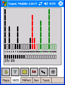
signal strength
TopoL Mobile includes tools to connect GNSS
and to display all parameters sent by GNSS (position, number and position of sattelites, signal quality, HDOP, PDOP etc.). TopoL Mobile enables to navigate to defined position, to move automatically the viewport by GNSS position, to make the measurement of point, lines and areas with automatic calculation of line length and area size and perimeter.
Measurement
During GNSS measurement one of several methods can be used. The position is registered
- always when data received
- after defined number of data received
- after defined time
- after distance passed
- as an average of defined number of data received
- as an average of data received during defined time period
In case of averaging in first step the standard deviation of measured values is calculated and in the second step new average is calculated from measured values, which fall inside this standard deviation. In that case the system is able to eliminate distant measurements and can get higher accuracy.
Attributing
Users can define that they want to have database attributes attached to each new object. They can create the database template with names and types of database attributes and with their definitions (Users can save any value into that attribute, value from defined interval or from a set of values).
I want to test it
You can download and test TopoL Mobile. If you install it it will work as demo version. It means that you can display all supported data formats, but new measured objects are not saved and the measured leangth or area size are not displayed. The navigation does not work as well. If you decide to buy it, you can just order it, register it and it will work in full version without reinstallation.